
Adams County Nebraska 14
Adams County Cameras
Towns in Adams County
Listings in Adams County
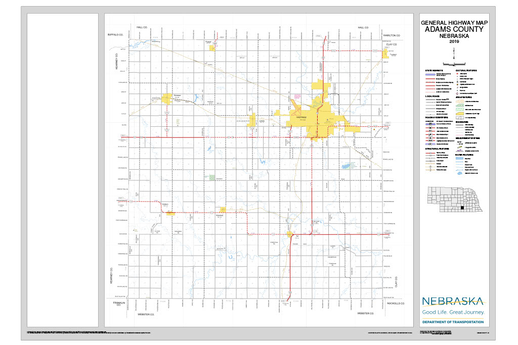
Adams County, Nebraska
County Seat: Hastings
Founded: 1867 (organized 1871)
Named For: John Adams, 2nd President of the United States
License Plate Prefix: 14
History
Adams County was authorized in 1867 and organized in 1871, named in honor of President John Adams. Early settlement was slow due to the harsh climate and lack of timber, but the arrival of the Burlington & Missouri River Railroad in 1872 transformed the region. Hastings, founded at the rail junction, quickly overtook Juniata as the county seat after a contested 1877 election. Agriculture flourished, with wheat, corn, and livestock forming the backbone of the economy. During World War II, Hastings hosted the Naval Ammunition Depot, the largest of its kind in the U.S., employing thousands and leaving a lasting mark on the county’s identity.
Geography
- Area: 564 sq mi (mostly land, with just 0.2% water)
- Major Highways: U.S. 6, U.S. 34, U.S. 281, Nebraska 74
- Transit: Hastings is a stop on Amtrak’s California Zephyr line
- Adjacent Counties: Hamilton (NE), Clay (E), Webster (S), Kearney (W), Buffalo (NW), Hall (N)
Culture & Landmarks
- Hastings is known as the “Birthplace of Kool‑Aid,” invented by Edwin Perkins in 1927.
- The county has 23 sites on the National Register of Historic Places, including Burlington Station and the Chautauqua Pavilion.
- The Adams County Historical Society preserves pioneer and WWII history, including Dust Bowl stories and rural school archives.
Notable Towns
- Hastings – largest city, county seat
- Juniata – first county seat, historic rail town
- Kenesaw – railroad heritage, small‑town pride
Events & Attractions
- Adams County Fairgrounds – Home to the annual Adams County Fairfest and the PRCA Oregon Trail Rodeo, plus year‑round concerts, craft shows, and community events.
- Kool‑Aid Days (Hastings) – A summer festival celebrating Hastings as the birthplace of Kool‑Aid, with parades, games, and family activities.
- Hastings Museum – Nebraska’s largest municipal museum, featuring natural history, regional history, and a planetarium.
- Spirit of the Plains Melon Roaster – A quirky local tradition highlighting the county’s agricultural roots.
- Downtown Hastings Events – Seasonal favorites like the Celebration of Lights, Farmers Markets, and the annual Veterans Day Parade.
Towns in Adams County
Hastings, Nebraska (68901)
County seat of Adams County and south-central Nebraska's largest city. Birthplace of Kool-Aid, home to Hastings College, and hub of the US-6/US-281 corridor.
Pop: ~24,000 | Highways: US-6, US-281, US-34 | Designation: County Seat
Ayr, Nebraska (68925)
A quiet agricultural village founded 1878 as a railroad grain shipping point, located 12 miles south of Hastings in Adams County.
Pop: ~150 | Highways: NE-74 | Designation: Village
Holstein, Nebraska (68950)
A US-6 corridor village with German immigrant roots, located at MM 193 between Kenesaw and Hastings.
Pop: ~200 | Highways: US-6 (MM 193) | Designation: Village
Juniata, Nebraska (68955)
Adams County's original county seat, founded 1871. Located at US-6 MM 207 just west of Hastings, with deep railroad history.
Pop: ~700 | Highways: US-6 (MM 207) | Designation: Original County Seat
Kenesaw, Nebraska (68956)
Birthplace of Grace Abbott and one of Adams County's more active small towns at US-6 MM 200, named after the Civil War's Battle of Kennesaw Mountain.
Pop: ~875 | Highways: US-6 (MM 200) | Designation: Corridor Town
Prosser, Nebraska (68883)
A small rural community at US-6 MM 187 near the Kearney County line, founded early 1900s as a railroad grain stop.
Pop: ~50 | Highways: US-6 (MM 187) | Designation: Unincorporated
Roseland, Nebraska (68973)
Named for the prairie wild roses, this southern Adams County village was founded early 1880s on NE-74 near the Webster County line.
Pop: ~200 | Highways: NE-74 | Designation: Village
Adams County, Nebraska (Plate #14)
County Seat: Hastings | Region: South Central Nebraska | Population: ~31,000 | Area: 564 sq mi
Adams County anchors south-central Nebraska at the crossroads of US-6, US-281, and US-34. Its county seat, Hastings, is the birthplace of Kool-Aid and home to Hastings College, Mary Lanning Healthcare, and Nebraska's largest municipal museum. The county's US-6 corridor connects seven communities across open agricultural plains between the Kearney County and Clay County lines.
Towns: Hastings · Juniata · Kenesaw · Holstein · Prosser · Ayr · Roseland
Adjacent Counties: Hamilton · Clay · Webster · Kearney · Buffalo · Hall