
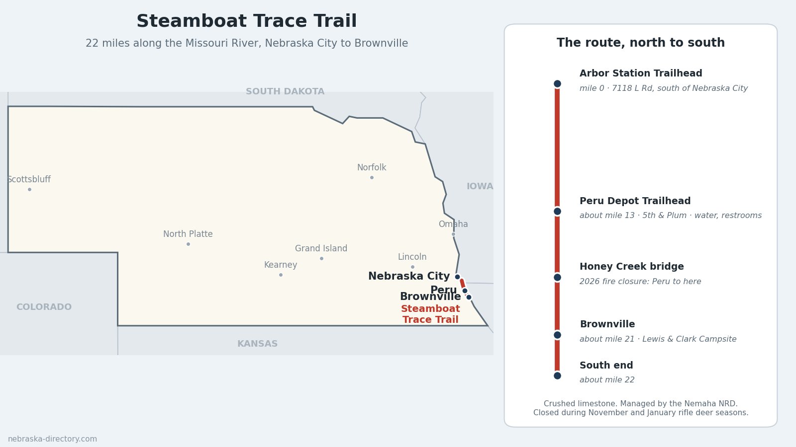
Steamboat Trace Trail: Missouri River Bluffs from Nebraska City to Brownville
The Steamboat Trace Trail is a 22-mile rail trail along the Missouri River in southeast Nebraska. It starts about six miles south of Nebraska City and runs south through Peru to just past Brownville, on a former railroad bed between wooded sandstone bluffs, farmland and the river. The trail is managed by the Nemaha Natural Resources District and is free to use.
Trail status: After a wildfire in late March 2026, the section from Peru south to the Honey Creek bridge was closed because of tree damage. The NRD expected it to reopen by October 1, 2026. Call the Nemaha NRD at (402) 335-3325 to confirm before you go. The trail also closes every year during the November and January rifle deer seasons.
Trail at a Glance
- Length: 22 miles (the Nemaha NRD's figure; other guides give 21 to 23).
- Surface: Crushed limestone, flat railroad grade.
- Uses: Walking, running and biking. No horses, ATVs, snowmobiles or other motor vehicles.
- Hours and fees: Open year-round in daylight hours. No fee or permit; donations are welcome.
- Managed by: Nemaha Natural Resources District, 62161 Hwy. 136, Tecumseh, (402) 335-3325. That is the office, not a trailhead.
- Counties: Otoe County at the north end; Nemaha County for Peru and Brownville.
Trailheads, North to South
- Arbor Station Trailhead (mile 0) — 7118 L Rd., south of Nebraska City. From U.S. 75, turn in at the OPPD Nebraska City Station entrance and turn right at the switchyard. Parking and a picnic shelter.
- Peru Depot Trailhead (about mile 13) — 5th and Plum streets. Parking, a picnic shelter, restrooms and drinking water.
- Brownville (about mile 21) — the Lewis & Clark Campsite parking area at 648A Ave. and E. Water St. Parking, with restrooms in town. The trail continues about a mile farther south.
What You'll See
The trail stays close to the Missouri River, under tall sandstone bluffs and through hardwood timber, with open farm views between. It crosses Camp Creek and Honey Creek on old railroad bridges and passes the site of Olson, a vanished railroad town. South of Peru, look for the sandstone carvings by local artist Roland Sherman cut into the bluff beside the trail. The National Park Service recognizes the trail as a Lewis & Clark site: the expedition camped near Brownville on July 15, 1804.
History
River towns along this stretch grew up on steamboat traffic. Brownville, founded in 1854 by Richard Brown as a trading post and ferry crossing, boomed in the 1850s and 1860s, then faded when the railroads took the trade and the county seat moved to Auburn in 1885. Much of the village is now the Brownville Historic District, on the National Register since 1970. Peru is home to Peru State College, founded as Mount Vernon School in 1865 and the state's first teachers college in 1867.
The trail follows a former Burlington railroad line along the river. After the track was abandoned, the Rails-to-Trails Conservancy rail-banked the corridor and deeded it to the Nemaha NRD in 1995, and the trail opened in October 1998. Floods in 2011 and 2019 closed parts of it for long stretches; the NRD celebrated a grand reopening at the Peru Depot in April 2023.
Nearby Places
- Arbor Lodge State Historical Park — J. Sterling Morton's mansion and arboretum, 2600 Arbor Ave., Nebraska City
- Missouri River Basin Lewis & Clark Visitor Center — 100 Valmont Dr., Nebraska City
- Kimmel Orchard & Vineyard — 5995 G Rd., Nebraska City
- Lied Lodge at Arbor Day Farm — lodging in Nebraska City
- Peru State College — 600 Hoyt St., Peru, a short ride from the Depot Trailhead
- Meriwether Lewis Dredge & Missouri River History Museum — a National Historic Landmark on the riverfront, Brownville
- Brownville Historical Society Museum at the Bailey House — Brownville
- Brownville Riverside Park & Landing — camping by the river, U.S. 136
- Indian Cave State Park — about 10 miles south of Brownville; park entry permit required
Related Trails and Corridors
- Lewis & Clark National Historic Trail — follows the Missouri River past the trail
- US Highway 75 — to the Arbor Station Trailhead
- US Highway 136 — through Brownville and across the Missouri River
- Nebraska Highway 2 — through Nebraska City
- ← All Nebraska Trails