
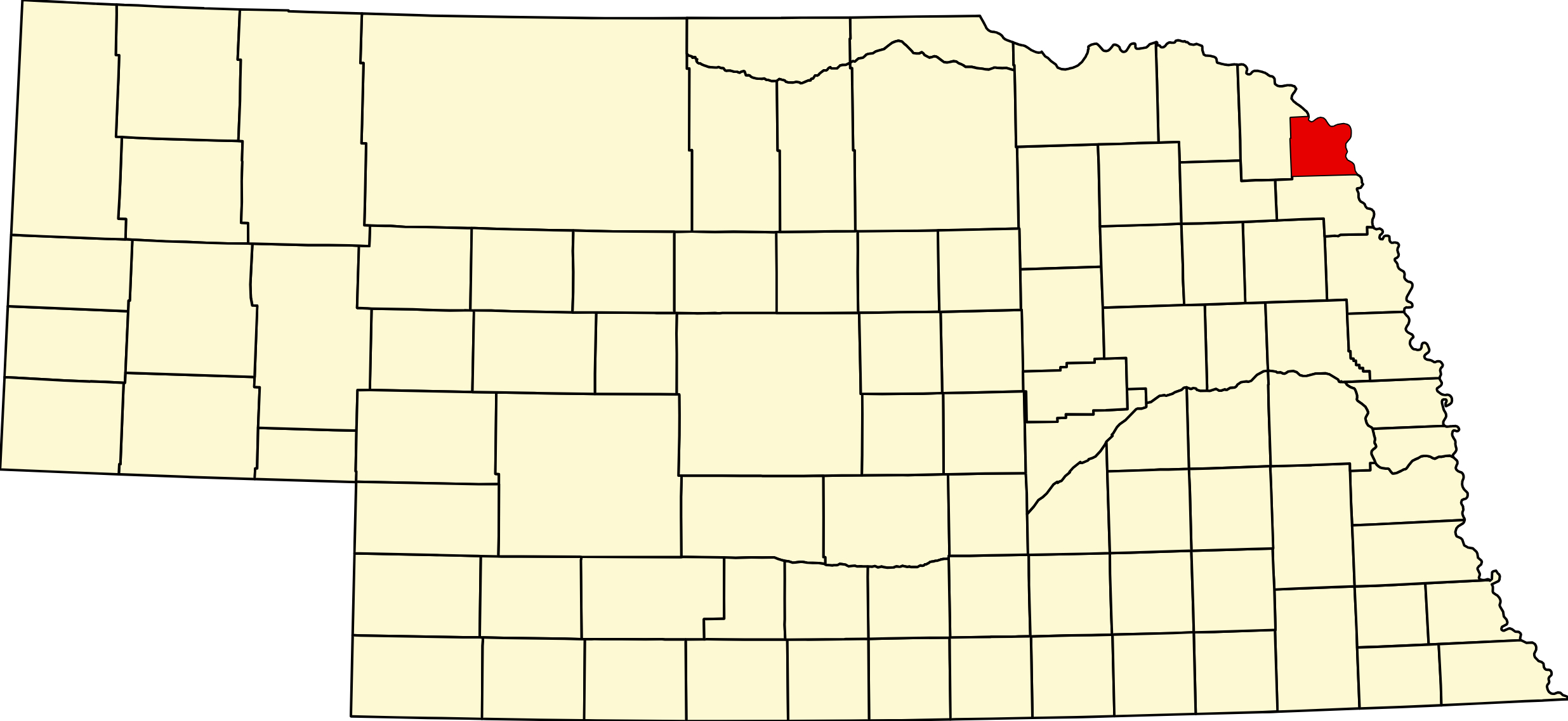
Towns in Dakota County Nebraska
Listings in Dakota County Nebraska

Dakota County, Nebraska
County seat: Dakota City · Created: 1855 · Named for: the Dakota (Sioux) people · License plate prefix: 70 · Population: 21,582 (2020 census) · Area: 267 sq mi
About Dakota County
Dakota County is a small, mostly urban county in northeastern Nebraska, on the Missouri River across from Sioux City, Iowa. The First Territorial Legislature created it in March 1855 and named it for the Dakota people; Dakota City has been the county seat since 1856. The population has risen at every census since 1860, to 21,582 in 2020, and about two-thirds of the county lives in South Sioux City.
The first towns were river towns: Dakota City, Covington (now part of South Sioux City) and the Irish Catholic colony of St. John's near today's Jackson. Railroads built from Covington from 1876 started Hubbard and Emerson, which the county shares with Dixon and Thurston counties; Homer grew up near Tonwantonga, the Omaha tribe's Big Village of about 1775 to 1845. The beef plant at Dakota City, opened by Iowa Beef Packers in 1966 and now run by Tyson, is the largest employer. Danish Alps State Recreation Area near Hubbard opened in 2015.
Towns of Dakota County
Cities and villages
Dakota City
The county seat since 1856, a city of 2,081 just south of South Sioux City. Its 1860 Emmanuel Lutheran Church is the oldest standing Lutheran church building in Nebraska; Cottonwood Cove river park, the Tyson beef plant and Cottonwood Days each June.
South Sioux City
Largest city in the county, 14,043 people facing Sioux City across the Missouri. Two bridges to Iowa, Scenic Park campground on the river, Siouxland Freedom Park, Covington Links golf, hotels and the Atokad racetrack.
Jackson
Village of 207 on US 20 west of South Sioux City, laid out about 1860 as Franklin near the Irish Catholic colony of St. John's. Brick St. Patrick's Church (1879–80), Lewis and Clark campsite marker, elementary school and a restaurant.
Homer
Village of 532 on US 75/77 south of Dakota City, near the site of the Omaha tribe's Big Village visited by Lewis and Clark. Homer Community Schools, the county historical society's O'Connor House museum and Landmand Golf Club.
Hubbard
Village of 153 on NE 35, laid out in 1880 on the Omaha Road and named for railroad president Asahel W. Hubbard. Gateway to Danish Alps State Recreation Area and its 219-acre Kramper Lake.
Emerson
Village of 840 where Dakota, Dixon and Thurston counties meet on Main Street (NE 9). Founded in 1881 at a railroad junction; National Register city park, clinic, RV park and Emerson-Hubbard schools.
Former towns and post office communities
Willis
Crossroads where NE 12 ends at US 20, about 4 miles west of Jackson. Maps and place-name records also call the spot Brady, Brady's Crossing and Vista.
Goodwin
Former railroad town and post office (1892–1940) about 2 miles southwest of Willis, named for railroad official John C. Goodwin.
Nacora
Former post office (1892–1943) in southwestern Dakota County between Emerson and Hubbard; its name is said to come from a Spanish word meaning "I am born."
Travel Corridors
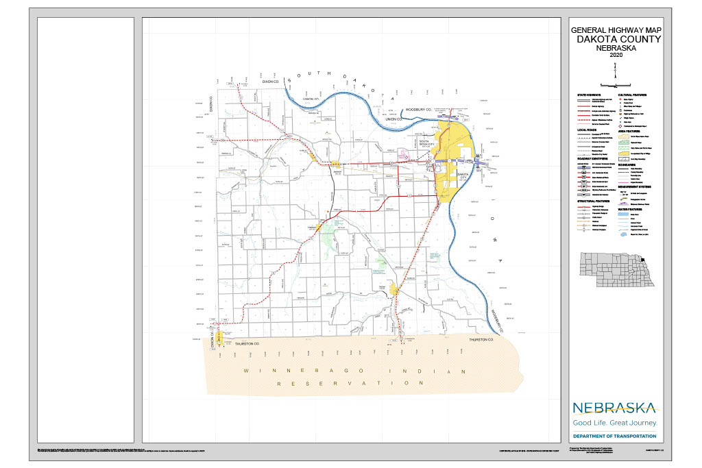
US Highway 20 — east–west across the north of the county from Willis, where NE 12 ends, past Jackson to South Sioux City, then with I-129 over the Sergeant Floyd Memorial Bridge into Iowa. US 20 Corridor →
US Highways 75 and 77 — north–south together from Winnebago past Homer and Dakota City; US 75 joins I-129, while US 77 follows Dakota Avenue through South Sioux City to the Siouxland Veterans Memorial Bridge. US 75 Corridor →
NE 35, NE 110 and NE 12 — NE 35 runs from Emerson through Hubbard to Dakota City; NE 110 links NE 35 with US 20 west of South Sioux City; NE 12, the Outlaw Trail Scenic Byway, begins at US 20 at Willis and heads to Ponca. NE 12 Corridor →
Dakota County Business Directory
Businesses within 20 miles of: South Sioux City · Dakota City · Homer · Jackson · Hubbard · Emerson · All listings →
Adjacent Counties
Dixon County (west) · Thurston County (south) · Woodbury County, Iowa (east, across the Missouri River) · Union County, South Dakota (north, across the Missouri River)
Events
The Dakota-Thurston County Fair is held at the fairgrounds on Stable Drive in South Sioux City in late July or early August.
Events in Dakota County
- Dakota County Fair (South Sioux City)
Dakota County Fair, a county fair in Dakota City, Nebraska.
Know of another event in the county? Tell us about it.
Outdoors — Camping, RV, Hunting & Fishing
Dakota County holds the newest full-scale state recreation area in Nebraska, and by some distance the most modern camping facility at this end of US-20.
Danish Alps State Recreation Area
1260 200th Street, Hubbard. (402) 632-4109. A 219-acre lake set in 520 acres of parkland, with water reaching 45 feet deep. Built by the Papio-Missouri River NRD to stabilize the Pigeon and Jones Creek watershed, the park opened on August 1, 2015 and is named for the Danish pioneers who settled the county.
Camping is the best on the corridor’s eastern end. The main loops hold 44 electric sites — 34 gravel pads, seven gravel pull-throughs and three accessible cement pads — plus 22 basic sites. A separate equestrian campground adds 29 electric pads with 14 horse corrals with hitching posts and water. There are also six kayak-in campsites reachable only by water or on foot. Amperage is not published — confirm when booking if you need 50 amp.
A dump station is confirmed on site — the only one at a state park in this corner of the state — though its exact location is not published, so ask at the entrance. Modern restrooms, coin-operated showers, water, and a fish-cleaning station added in 2017.
Read this before a late-season trip: Game and Parks states that full-hookup service, showers, modern restrooms and the dump and fill station are closed from mid-October through April, with off-season rates $5 lower. The campground has been listed as open through mid-October. Assume no dump, no showers and no water through the winter.
Half the electric sites are reservable up to 180 days ahead during the peak season, April 15 to October 15, on 1-844-637-2757; the rest are first come, paid at an iron ranger. A park entry permit is required on top of camping fees.
Fishing
Kramper Lake at Danish Alps is the county’s main still water, deep enough at 45 feet to hold fish through a hot summer, with a fish-cleaning station on site. The Missouri River along the eastern boundary gives channel and flathead catfish, and river access is available from the South Sioux City riverfront. A park entry permit is required at Danish Alps in addition to a fishing permit.
Trails and the riverfront
South Sioux City has a developed Missouri riverfront with trails and parks looking across to Sioux City, Iowa — the natural first or last stop on a US-20 journey across Nebraska, and the only place on the corridor with full metropolitan services.
Hunting in the county is largely private ground and river-bottom whitetail; Open Fields and Waters walk-in tracts change annually, so check the current Public Access Atlas.
Dakota County at a Glance
Dakota County, Nebraska — the small, densely settled county in the state’s northeast corner where the Missouri River turns, and the eastern end of US-20 in Nebraska. County seat Dakota City; South Sioux City is much the larger place, facing Sioux City, Iowa across the river. 232 listings across 9 towns.
Getting there: US-20, US-77 and I-129 all meet here; the Missouri River bridges cross into Sioux City, Iowa.
For visitors: the Missouri River frontage at South Sioux City, with riverfront trails and parks looking across to Sioux City. This is the metropolitan end of the corridor — full services, and the natural first or last stop on a US-20 journey across Nebraska.
Vehicles registered in Dakota County carry license plate number 70. See what every Nebraska county number means.
Dakota County Businesses & Places
231 listings in Dakota County.
Click a category to see the businesses.
Eat & Drink (30)
- Arby's South Sioux City — Arby's, Nebraska
- Burger King South Sioux City — Burger King, Nebraska
- Chinese Chef — Chinese Restaurant, Nebraska
- Crystal Cafe — Cafe / Coffee Shop, Nebraska
- Crystal Café South Sioux City — American Restaurant, Nebraska
- Daga's on Broadway — Steakhouse, Dakota City
- Deanda's — Mexican Restaurant, Nebraska
- El Ranchito South Sioux City — Mexican Restaurant, Nebraska
- Greek to Me Dakota Avenue — Greek Restaurant, Nebraska
- Jimmy John's - South Sioux City (904 Dakota Ave) — Jimmy John's, Nebraska
- Kahill's Chophouse — Steakhouse, Nebraska
- Krueger's Korner — Bar & Grill, Hubbard
- La Isla Restaurant South Sioux City — Mexican Restaurant, Nebraska
- La Morena Family Restaurant — Diner / Family Restaurant, Nebraska
- Little Caesars South Sioux City — Little Caesar's, Nebraska
- McDonald's - Dakota City (600 Dakota Ave) — McDonald's, Dakota City
- Mi Familia Mexican Restaurant South Sioux City — Mexican Restaurant, Nebraska
- Mi Rancherita — Mexican Restaurant, Nebraska
- Namaste Indian Resto — Indian Restaurant, Nebraska
- Palermo Italian Cuisine and Bar — Italian Restaurant, Jackson
- Panda Palace — Chinese Restaurant, Nebraska
- Pizza Hut South Sioux City — Pizza Restaurant, Nebraska
- Rosie's Pizza South Sioux City — American Restaurant, Nebraska
- Subway – 2720 Dakota Ave, South Sioux City — Subway, Nebraska
- Taco Bell South Sioux City — Mexican Restaurant, Nebraska
- Taco John's South Sioux City — Taco John's, Nebraska
- Townhouse Cafe — Cafe / Coffee Shop, Nebraska
- Trattoria Fresco South Sioux City — Italian Restaurant, Nebraska
- Wendy's South Sioux City — Wendy's, Nebraska
- Yummy House — American Restaurant, Nebraska
Stay (3)
- Cottonwood Inn and Conference Center — Hotel, Nebraska
- Knights Inn South Sioux City — Motel, Nebraska
- South Sioux City Marriott Riverfront — Hotel, Nebraska
Outdoors & Recreation (9)
- Basswood Ridge WMA — Public Hunting Areas & WMAs, Homer
- Covington Links Golf Course — Golf Course, Nebraska
- Crystal Cove Disc Golf Course — Disc Golf Course, Nebraska
- Danish Alps State Recreation Area — Campgrounds & RV Parks, Hubbard
- Landmand Golf Club — Golf Course, Homer
- Old Dane Golf Club — Golf Course, Dakota City
- Omadi Bend WMA — Public Hunting Areas & WMAs, Homer
- Scenic Park Campground — Campgrounds & RV Parks, Nebraska
- South Ridge Golf Course — Golf Course, Nebraska
Places to Visit (9)
- Cottonwood Cove Park – Dakota City — City Parks, Dakota City
- Crystal Cove Park – South Sioux City — City Parks, Nebraska
- Dakota County Historical Society and O’Connor House Museum — History & Heritage Museums, Homer
- Danish Alps State Recreation Area — RV Camping, Hubbard
- Lewis and Clark Campsite Marker – Jackson — Historic Marker, Jackson
- Lewis and Clark Wayside — Specialty Museums, Dakota City
- Siouxland Freedom Park — City Parks, Nebraska
- The Brigadier General Bud and Doris Day Interpretive Center — Museum, Nebraska
- Tonwantonga (Omaha Big Village) Marker – Homer — Historic Marker, Homer
Events & Venues (2)
- Dakota County Fair — County Fair, Nebraska
- Dakota County Fairgrounds — Fairground, Nebraska
Health & Emergency (6)
- Emerson Medical Clinic — Medical Clinic, Emerson
- Knotted Tree Massage Therapy — Massage, Nebraska
- Siouxland Community Health Center – South Sioux City — Medical Clinic, Nebraska
- Siouxland Mental Health Center – South Sioux City — Mental Health Service, Nebraska
- Tri-State Physicians & Physical Therapy Clinic — Massage, Nebraska
- UnityPoint Clinic Family Medicine – South Sioux City — Medical Clinic, Nebraska
Travel Services (1)
- ChargePoint Charging Station — Electric Vehicle Charging Station, Nebraska
Shopping & Gifts (3)
- Dollar General Dakota City — Retail, Dakota City
- Northeast Nebraska Telephone Company — Cell Phone Store, Jackson
- Walmart Supercenter South Sioux City — Department store, Nebraska
Community & Faith (43)
- Amateur Radio Repeaters - Dakota County (via RepeaterBook.com) — Amateur Radio Repeater, Nebraska
- Boals Family Plot — Dakota City — Cemeteries, Dakota City
- Calvary Cemetery — Emerson — Cemeteries, Emerson
- Cedar Heights Cemetery — Cemeteries, Dakota City
- Centro Internacional Casa de Oracion Assembly of God — Pentecostal, Nebraska
- Dakota City Cemetery — Dakota City — Cemeteries, Dakota City
- Dakota City UMC — Methodist Church, Dakota City
- Drake Cemetery — Jackson — Cemeteries, Jackson
- Emmanuel Lutheran Church – Dakota City — Lutheran Church, Dakota City
- First Lutheran Church — Lutheran Church, Nebraska
- Green Valley Cemetery — Homer — Cemeteries, Homer
- Hale Cemetery — Hubbard — Cemeteries, Hubbard
- Hilltop Cemetery — Hubbard — Cemeteries, Hubbard
- Homer UMC — Methodist Church, Homer
- Hope Lutheran Church — Lutheran Church, Nebraska
- Jopp Cemetery — Cemeteries, Emerson
- King's Sioux City Marshallese — Pentecostal, Nebraska
- Living Water EFC — Evangelical Free Church, Nebraska
- Norm Waitt Sr. YMCA — Civic & Community Organizations, Nebraska
- Old Log Church Cemetery — Nacora — Cemeteries, Nacora
- Omadi Cemetery — Homer — Cemeteries, Homer
- Omaha Valley Cemetery — Homer — Cemeteries, Homer
- River Hills Church of the Assemblies of God — Pentecostal, Nebraska
- Roost Cemetery — Dakota City — Cemeteries, Dakota City
- Rose Hill Cemetery — Emerson — Cemeteries, Emerson
- Sacred Heart Catholic Church Emerson — Catholic Church, Emerson
- Saint Cornelius Cemetery — Homer — Cemeteries, Homer
- Saint Johns Cemetery — Jackson — Cemeteries, Jackson
- Saint Mary's Cemetery — Hubbard — Cemeteries, Hubbard
- Saint Michaels Calvary Cemetery — South Sioux City — Cemeteries, Nebraska
- Salem Lutheran Church — Lutheran Church, Dakota City
- South Sioux City St Paul UMC — Methodist Church, Nebraska
- St. Cornelius Mission Homer — Catholic Church, Homer
- St. Luke Lutheran Church — Lutheran Church, Emerson
- St. Mary Mission Hubbard — Catholic Church, Hubbard
- St. Michael Catholic Church South Sioux City — Catholic Church, Nebraska
- St. Patrick Church Jackson — Catholic Church, Jackson
- St. Paul's Lutheran Church — Lutheran Church, Homer
- St. Paul's Lutheran Church — Lutheran Church, Emerson
- Taylor Cemetery — Homer — Cemeteries, Homer
- Taylor Family Plot — Homer — Cemeteries, Homer
- Trinity Lutheran Church — Lutheran Church, Hubbard
- Woods Family Plot — Nacora — Cemeteries, Nacora
Automotive (42)
- A-1 Crashed Cars Auto Sales — Salvage Yard, Nebraska
- America Auto — Used Car Dealer, Nebraska
- Broadway Auto Sales — Used Car Dealer, Nebraska
- C & H Truck Sales — Truck Dealership, Nebraska
- Cardinal Auto — Used Car Dealer, Dakota City
- Casey's General Store - South Sioux City — Casey's, Nebraska
- Covenant Auto Sales — Used Car Dealer, Nebraska
- D & R Auto Sales — Used Car Dealer, Nebraska
- Dakota Auto — Used Car Dealer, Dakota City
- Dakota Food & Fuel — Fuel & Gas Station, Dakota City
- Daves Used Cars — Used Car Dealer, Homer
- Daytona Auto — Used Car Dealer, Nebraska
- DC Auto Sales — Used Car Dealer, Dakota City
- Deanda Auto Sales — Used Car Dealer, Nebraska
- Economy Transmission — Auto Repair, Nebraska
- Equipt Truck and Machinery — Truck Dealership, Nebraska
- HG Auto — Used Car Dealer, Nebraska
- Highway 20 Sales — Used Car Dealer, Nebraska
- HNH Auto Repair — Auto Repair, Emerson
- Hubbard Mini Mart — Fuel & Gas Station, Hubbard
- Ken Bar Leasing — Used Car Dealer, Nebraska
- Kuehn Auto Sales — Used Car Dealer, Nebraska
- L & D Auto Sales — Used Car Dealer, Nebraska
- Los Altos Auto Sales — Used Car Dealer, Nebraska
- Martinez Auto Sales — Used Car Dealer, Nebraska
- Mid City Motors — Used Car Dealer, Nebraska
- Motoplex of Siouxland — Motor Sports, Nebraska
- MT Repair — Auto Repair, Jackson
- National Motor Sales — Used Car Dealer, Nebraska
- Neal Auto Sales — Used Car Dealer, Nebraska
- Odells Auto Sales and Service — Auto Repair, Dakota City
- Phillips Family Auto Repair — Auto Repair, Homer
- Prime Performance Auto Repair — Auto Repair, Nebraska
- Pump & Pantry - Jackson — Pump & Pantry, Jackson
- Rick's Radiator & Heater Repair — Auto Parts, Nebraska
- River Auto Sales — Used Car Dealer, Nebraska
- Small Town Muscle Cars — Classic & Collector Cars, Homer
- Stapleton Salvage — Salvage Yard, Nebraska
- Supreme Motors — Used Car Dealer, Nebraska
- SV Auto Sales — Used Car Dealer, Nebraska
- Taylor & Martin Motor Sales — Used Car Dealer, Nebraska
- United Auto — Used Car Dealer, Nebraska
Government & Resources (40)
- ACCESSNebraska Office - South Sioux City — Developmental & Social Services, Nebraska
- Dakota City Fire Department — Fire Station, Dakota City
- Dakota City Post Office — Post Office, Dakota City
- Dakota City Public Library — Libraries, Dakota City
- Dakota City USDA Service Center — USDA Service Center (FSA/NRCS), Dakota City
- Dakota County Assessor — County Assessor, Dakota City
- Dakota County Attorney's Office — County Attorney, Dakota City
- Dakota County Clerk — County Clerk, Dakota City
- Dakota County Court — County Court, Dakota City
- Dakota County Courthouse — Court House, Dakota City
- Dakota County Driver License Office — County Driver License, Dakota City
- Dakota County Emergency Management — Emergency Management, Nebraska
- Dakota County Health Department — County/District Health Department, Dakota City
- Dakota County Sheriff — County Sheriff, Dakota City
- Dakota County Treasurer — County Treasurer, Dakota City
- Dakota County Veterans Service Office — Veterans Office, Dakota City
- Dakota County Weed Superintendent — County Weed Control, Dakota City
- Emerson Fire & Rescue — Fire Station, Emerson
- Emerson Housing Authority — Housing Authority, Emerson
- Emerson Police Department — Police Station, Emerson
- Emerson Post Office — Post Office, Emerson
- Emerson Public Library — Libraries, Emerson
- Emerson Village Office — City Hall, Emerson
- Emerson–Hubbard Food Pantry — Food Pantry, Emerson
- Homer Fire Department — Fire Station, Homer
- Homer Post Office — Post Office, Homer
- Hubbard Post Office — Post Office, Hubbard
- Hubbard Village Office — City Hall, Hubbard
- Jackson Post Office — Post Office, Jackson
- Jackson Public Library — Libraries, Jackson
- Jackson Village Office — City Hall, Jackson
- Northeast Nebraska Senior Citizens, Inc. — Senior Citizen Center, Nebraska
- Siouxland Interstate Metropolitan Planning Council (SIMPCO) — Economic development agency, Nebraska
- South Sioux City Area Chamber of Commerce & Tourism — Chamber of Commerce, Nebraska
- South Sioux City City Hall — City Hall, Nebraska
- South Sioux City Fire Department — Fire Station, Nebraska
- South Sioux City Housing Agency — Housing Authority, Nebraska
- South Sioux City Police Department — Police Station, Nebraska
- South Sioux City Post Office — Post Office, Nebraska
- South Sioux City Public Library — Libraries, Nebraska
Education (18)
- Cardinal Elementary School — Elementary & Middle School, Nebraska
- Covington Elementary School — Elementary & Middle School, Nebraska
- Dakota City Elementary School — Elementary & Middle School, Dakota City
- Dakota County Extension — County Extension Office, Dakota City
- E N Swett Elementary School — Elementary & Middle School, Nebraska
- Emerson-Hubbard Elementary Sch — Elementary & Middle School, Emerson
- Emerson-Hubbard High School — High School, Emerson
- Emerson-Hubbard Middle School — Elementary & Middle School, Emerson
- Emerson-Hubbard Public Schools — School District (K-12 / General), Emerson
- Harney Elementary School — Elementary & Middle School, Nebraska
- Homer Community Schools — School District (K-12 / General), Homer
- Homer Elementary School — Elementary & Middle School, Homer
- Homer High School — High School, Homer
- Jackson Elementary — Elementary & Middle School, Jackson
- Lewis & Clark Elementary Sch — Elementary & Middle School, Nebraska
- South Sioux City Community Schools — School District (K-12 / General), Nebraska
- South Sioux City Middle School — Elementary & Middle School, Nebraska
- South Sioux High School — High School, Nebraska
Utilities (9)
- City of Dakota City — Water Utility / District, Dakota City
- City of South Sioux City — Water Utility / District, Nebraska
- Emerson Municipal Utilities — Electric Power Provider, Emerson
- Northeast Nebraska Telephone Company — Telephone & Internet Provider, Jackson
- South Sioux City Municipal Utilities — Electric Power Provider, Nebraska
- Village of Emerson — Water Utility / District, Emerson
- Village of Homer — Water Utility / District, Homer
- Village of Hubbard — Water Utility / District, Hubbard
- Village of Jackson — Water Utility / District, Jackson
Professional Services (5)
- Diversified Insurance of Nebraska — Insurance, Nebraska
- F&M Bank South Sioux City — Banking, Nebraska
- Northeast Nebraska Insurance Agency – South Sioux City — Insurance, Nebraska
- South Sioux Self Storage – South Sioux City Gateway Dr — Self-Storage Facility, Nebraska
- Tri-State Communications — Two-Way Radio Sales & Service, Nebraska
Media (4)
- American Family Radio 91.3 FM - Hubbard — American Family Radio, Hubbard
- Dakota County Star — News Paper, Nebraska
- KSFT 107.1 FM - South Sioux City — Radio Station, Nebraska
- KZOI 1250 AM - Dakota City — Radio Station, Dakota City
Agriculture & Farm (4)
- Empirical Foods, Inc. — Packing House, Nebraska
- J.E. Meuret Grain Co. Inc. - Dakota City — Grain Elevator, Dakota City
- Richardson Milling – South Sioux City — Grain Elevator / Cooperative, Nebraska
- Tyson Fresh Meats – Dakota City — Packing House, Dakota City
Transportation (3)
- Martin Field — South Sioux City — Municipal / General Aviation Airport, Nebraska
- Sioux City Transit - South Sioux City — Public Transportation, Nebraska
- Sioux Gateway Airport (Col. Bud Day Field) — Commercial Airport, Nebraska
Personal Services (1)
- D'Elegance Beauty Bar — Beauty Salon, Nebraska
Manufacturing & Industrial (1)
- Richardson Milling – South Sioux City — Food & Beverage Manufacturing, Nebraska