
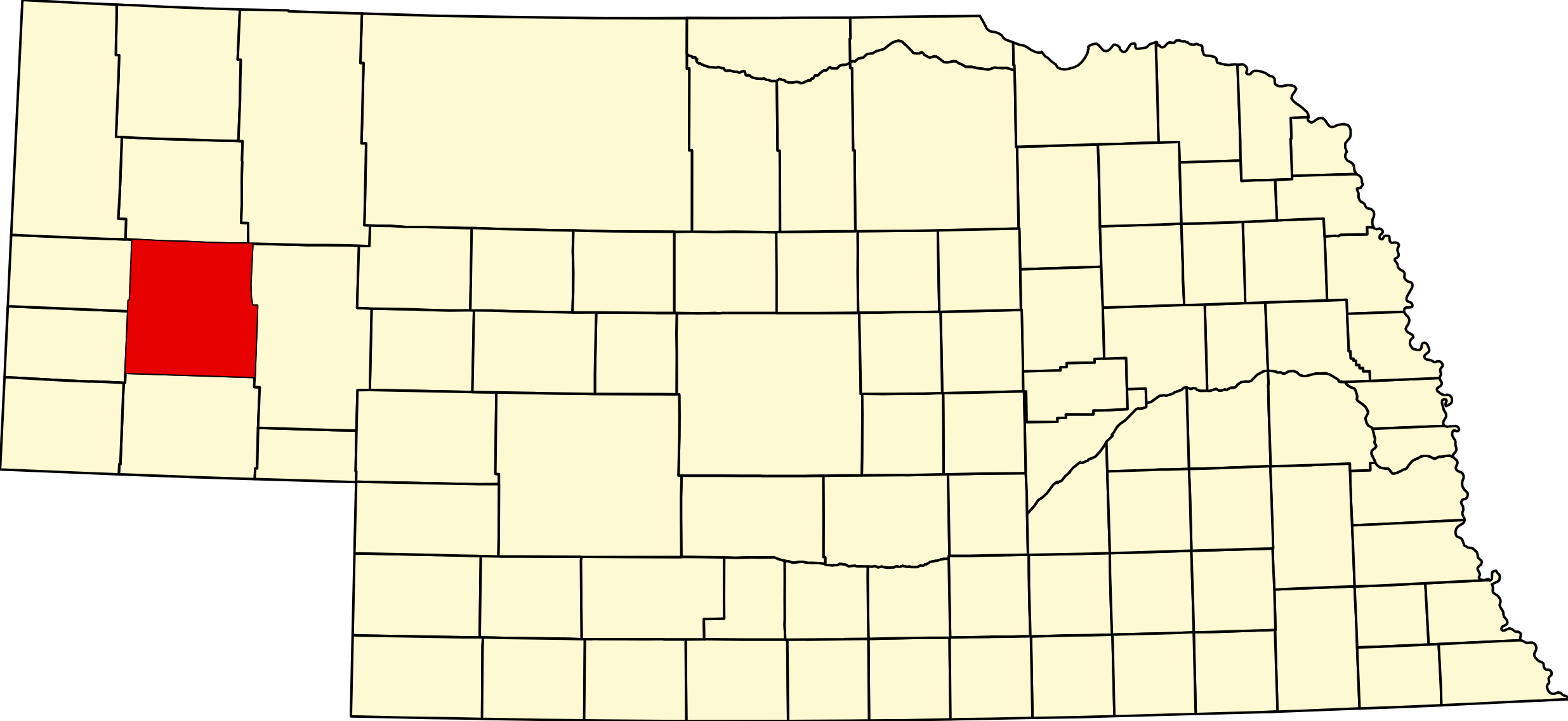
Morrill County, Nebraska
County seat: Bridgeport · Created: November 3, 1908, by vote of Cheyenne County; separated March 9, 1909 · Named for: Charles Henry Morrill, president of the Lincoln Land Company · License plates: prefix 64 · Population: 4,555 (2020 census); peak 9,950 in 1930 · Area: 1,430 sq mi (1,424 land) · Time zone: Mountain
About Morrill County
Morrill County is trail country in the North Platte valley of the Panhandle, where Chimney Rock and Courthouse and Jail Rocks stand off the south rim of the valley. Its cities are Bridgeport, the county seat, and Bayard; Broadwater is a village, and Angora, Northport and Redington are smaller places. It borders Box Butte County on the north, Sheridan on the northeast, Garden on the east, Cheyenne on the south, Banner on the southwest and Scotts Bluff on the west. (The village of Morrill is in Scotts Bluff County.) Its eight National Register listings include Chimney Rock, Courthouse and Jail Rocks, the courthouse, the Camp Clarke Bridge site, Mud Springs and the Rush Creek battlefield.
The Oregon–California and Mormon trails, the Pony Express and the Sidney–Black Hills road all crossed the county. In February 1865 Cheyenne and Lakota warriors attacked the Mud Springs station and fought soldiers at Rush Creek near Broadwater. Henry T. Clarke’s toll bridge of 1875–76 carried gold seekers over the river west of present Bridgeport, and the Burlington laid out Bridgeport, moved Bayard and founded Angora in 1899–1900. Cheyenne County voters split off the northern part as Morrill County on November 3, 1908; Bridgeport won the seat over Bayard, 575 to 375. Sugar beets and irrigation brought the county to 9,950 people in 1930. On March 12, 2026, wind gusts of 70–80 mph snapped a power pole northeast of Bridgeport and started the Morrill Fire, which burned about 643,000 acres across five counties, the largest wildfire in Nebraska history.
Towns of Morrill County
Cities and villages
Bridgeport
Morrill County seat of 1,454 where US 26 and US 385 cross the North Platte: Courthouse and Jail Rocks 5 miles south, Bridgeport State Recreation Area's five lakes and 80 campsites, and the Camp Clarke trail-crossing history.
Bayard
City of 1,140 on US 26, about 4 miles north of Chimney Rock: the 1928 depot museum, a full-hookup RV park at the base of the rock, and Chimney Rock Pioneer Days each September.
Broadwater
Village of 95 on US 26 where NE 92 rejoins it, near the Ancient Bluff Ruins of the Mormon Trail and the 1865 Rush Creek battlefield.
Angora
Small railroad community on US 385, the Gold Rush Byway, 13 miles north of Bridgeport, named for Angora (Ankara), Turkey; it keeps its own post office.
Redington
Former post office and ranch settlement in southwestern Morrill County, about 11 miles west-southwest of Bridgeport and 8 miles west of Courthouse Rock.
Northport
Railroad settlement on the north bank of the North Platte across from Bridgeport; its post office ran from 1910 to 1975.
Former towns and post office communities
Vance
Former Burlington point north of the North Platte, about 8 miles north of Bridgeport, in Camp Clarke precinct.
Simla
Former place in Union precinct, southern Morrill County, also called Mud Springs Station; near the Mud Springs Pony Express site.
Kelly
Former place in King precinct (also spelled Kelley), on the 1912 map of Morrill County.
Chimney Rock
Former station named for the landmark, in Court House precinct; Chimney Rock National Historic Site is about 4 miles south-southwest of Bayard.
Bonner
Former Burlington station in northern Morrill County, about 13½ miles southwest of Alliance.
Atkins
Former Burlington station in the North Platte valley between Bayard and Bridgeport, named for Col. A. W. Atkins.
Travel Corridors
US 26 follows the North Platte through Bayard, Bridgeport and Broadwater. US 385, the Gold Rush Byway, runs north through Angora to Alliance and south to Sidney, crossing the river with US 26 at Bridgeport. NE 92 runs west from Bridgeport past Chimney Rock to Gering and east along the south side of the valley to Broadwater. Highway 92 Corridor → NE 88 starts in Bridgeport and runs south past Courthouse and Jail Rocks into Banner County. No Interstate enters the county.
Cameras: View Morrill County cameras → · Road conditions: Nebraska 511
Landmarks and Outdoors
Chimney Rock National Historic Site, 9822 County Road 75, about 4 miles south of Bayard, (308) 586-2581, is a National Park Service affiliated site run by History Nebraska; the rock stands about 300 feet above the valley, and the Abbott Visitor Center has the trail exhibits. Admission $5 for adults and $3 for ages 5–18; from October through April it is open Tuesday–Saturday 9–4 Mountain. Courthouse and Jail Rocks, about 5 miles south of Bridgeport on NE 88, rise some 400 feet above the valley on 917 acres and are open without a fee.
Bridgeport State Recreation Area, 100 Recreation Road, (308) 783-2911, has about 326 acres with five sandpit lakes and 80 basic campsites, first come, first served, paid by cash or check, with an RV dump station and a swimming area on Center Lake; a park entry permit is required. Chimney Rock Pioneer Crossing near Bayard has 16 full-hookup pull-through sites. For hunting, the Faucus Springs wetlands of the Fliesbach WMA (433 acres, east of Chimney Rock) and Arnold Trupp WMA (6 miles north of Bayard) are open to the public.
Things to See
In Bridgeport: the 1909–10 courthouse and the Pioneer Trails Museum. In Bayard: the Bayard Depot Museum. Near Broadwater: the Ancient Bluff Ruins. On US 385 south of Bridgeport: Mud Springs Station.
Morrill County Business Directory
Businesses within 20 miles of: Bridgeport · Bayard · All listings →
Adjacent Counties
Box Butte County (north) · Sheridan County (northeast) · Garden County (east) · Cheyenne County (south) · Banner County (southwest) · Scotts Bluff County (west).
Events
Camp Clarke Days in Bridgeport at the end of May; Broadwater Days in June; the Camp Clarke Stampede rodeo on July 3–4; the Morrill County Fair in Bridgeport (July 18–25 in 2026); a Greek Festival in August; and Chimney Rock Pioneer Days in Bayard in September.
Events in Morrill County
- Camp Clarke Days (Bridgeport)
Camp Clarke Days is held in Bridgeport, Nebraska, in late May or on the first weekend of June. - Chimney Rock Pioneer Days (Bayard)
- Morrill County Fair (Bridgeport)
Morrill County Fair, a county fair in Bridgeport, Nebraska.
Know of another event in the county? Tell us about it.
Morrill County at a Glance
Morrill County, Nebraska — 1,430 square miles of North Platte valley and tableland with 4,555 people, county seat Bridgeport. 146 listings across 19 towns. Mountain Time.
Getting there: US 26 up the North Platte from Ogallala or down from Scottsbluff; US 385, the Gold Rush Byway, from Sidney or Alliance; NE 92 from Gering past Chimney Rock.
For visitors: Chimney Rock and Courthouse and Jail Rocks on the Oregon Trail, camping and fishing at Bridgeport State Recreation Area, and a hospital in Bridgeport.
Vehicles registered in Morrill County carry license plate number 64. See what every Nebraska county number means.
Morrill County Businesses & Places
146 listings in Morrill County.
Click a category to see the businesses.
Eat & Drink (10)
- Bobbi Jo's Branding Iron — American Restaurant, Bayard
- BurgerWerx — American Restaurant, Bridgeport
- Corner Cafe — Cafe / Coffee Shop, Bayard
- Daily Dose Coffee — Cafe / Coffee Shop, Bayard
- Frankies Bar N Grill — Bar & Grill, Bridgeport
- Karette Drive-In — Drive-In, Bridgeport
- Mi Puerto — Mexican Restaurant, Bridgeport
- Simple Co. Coffeehouse & Floral Shop — Cafe / Coffee Shop, Bridgeport
- Subway – 111 E 8th St, Bridgeport — Subway, Bridgeport
- The Rock Brew & Bakery — Bakery, Bayard
Stay (5)
- Chimney Rock Pioneer Crossing — RV Park, Bayard
- Cobblestone Inn & Suites - Bridgeport — Hotel, Bridgeport
- Landmark Inn — Hotel, Bayard
- Meadowlark Motor Inn & Restaurant — Hotel, Bridgeport
- Motel West Way — Hotel, Bridgeport
Outdoors & Recreation (8)
- Arnold Trupp WMA — Public Hunting Areas & WMAs, Bayard
- Bayard City Campground — Campgrounds & RV Parks, Bayard
- Bridgeport State Recreation Area — Campgrounds & RV Parks, Bridgeport
- Chet and Jane Fliesbach WMA — Public Hunting Areas & WMAs, Bayard
- Chimney Rock Golf Course — Golf Course, Bayard
- Chimney Rock Pioneer Crossing — Campgrounds & RV Parks, Bayard
- Court House and Jail Rock Golf Course — Golf Course, Bridgeport
- Meadow Park Motel & RV Park — Campgrounds & RV Parks, Bridgeport
Places to Visit (9)
- Ancient Bluff Ruins (Mormon Trail Wayside) — Historic Marker, Broadwater
- Bayard Depot Museum — Specialty Museums, Bayard
- Bridgeport State Recreation Area — State Recreation Areas, Bridgeport
- Camp Clarke Bridge Site — Historic Marker, Bridgeport
- Chimney Rock National Historic Site — National Historic Sites, Bayard
- Courthouse and Jail Rocks — Historic Marker, Bridgeport
- Mud Springs Station (Pony Express Site) — Historic Marker, Nebraska
- Pioneer Trails Museum — History & Heritage Museums, Bridgeport
- Rush Creek Battlefield — Historic Marker, Broadwater
Events & Venues (6)
- Camp Clarke Days — Festivals & Celebrations, Bridgeport
- Chimney Rock Pioneer Days — Festivals & Celebrations, Bayard
- Flex Fitness 2.1 — Gym, Bayard
- Morrill County Fair — County Fair, Bridgeport
- Morrill County Fairgrounds — Fairground, Bridgeport
- The Vault Studio & Events — Event Venue / Banquet Hall, Bayard
Health & Emergency (6)
- Chimney Rock Chiropractic — Chiropractor, Bayard
- Chimney Rock Medical Center — Medical Clinic, Bayard
- Morrill County Community Hospital — Hospital, Bridgeport
- Morrill County Hospital Clinic/Post — Medical Clinic, Bridgeport
- Nein Pharmacy and Gifts — Pharmacy, Bridgeport
- Prairie Therapeutic Massage — Massage, Bayard
Travel Services (1)
- Morrill County Visitors Committee — Bridgeport
Shopping & Gifts (5)
- Al's Market — Grocery, Bayard
- Dollar General - Bayard — Dollar Store, Bayard
- North of the Rock Designs — Gift shop, Bayard
- Serda-Fide Glass — Glass & Mirror Shop, Bayard
- Tiger Paws — Retail, Bayard
Government & Resources (29)
- Bayard Fire Department — Fire Station, Bayard
- Bayard Housing Authority — Housing Authority, Bayard
- Bayard Police Department — Police Station, Bayard
- Bayard Post Office — Post Office, Bayard
- Bayard Public Library — Libraries, Bayard
- Bayard Senior Center — Senior Citizen Center, Bayard
- Bridgeport Fire Department — Fire Station, Bridgeport
- Bridgeport Food Pantry — Food Pantry, Bridgeport
- Bridgeport Housing Authority — Housing Authority, Bridgeport
- Bridgeport Police Department — Police Station, Bridgeport
- Bridgeport Post Office — Post Office, Bridgeport
- Bridgeport Public Library — Libraries, Bridgeport
- Bridgeport Senior Center (Prairie Winds Community Center) — Senior Citizen Center, Bridgeport
- Bridgeport USDA Service Center — USDA Service Center (FSA/NRCS), Bridgeport
- Broadwater Post Office — Post Office, Broadwater
- Broadwater Public Library — Libraries, Broadwater
- Chimney Rock Villa — Assisted Living, Bayard
- Morrill County Assessor — County Assessor, Bridgeport
- Morrill County Attorney's Office — County Attorney, Bridgeport
- Morrill County Clerk — County Clerk, Bridgeport
- Morrill County Court — County Court, Bridgeport
- Morrill County Courthouse — Court House, Bridgeport
- Morrill County Driver License Office — County Driver License, Bridgeport
- Morrill County Emergency Management — Emergency Management, Nebraska
- Morrill County Sheriff — County Sheriff, Bridgeport
- Morrill County Treasurer — County Treasurer, Bridgeport
- Morrill County Veterans Service Office — Veterans Office, Bridgeport
- Morrill County Weed Superintendent — County Weed Control, Bridgeport
- Prairie Winds Chamber of Commerce — Chamber of Commerce, Bridgeport
Community & Faith (19)
- Alden Cemetery — Broadwater — Cemeteries, Broadwater
- All Souls Catholic Church Bridgeport — Catholic Church, Bridgeport
- Amateur Radio Repeaters - Morrill County (via RepeaterBook.com) — Amateur Radio Repeater, Nebraska
- Angora Cemetery — Angora — Cemeteries, Angora
- Bayard Cemetery — Bayard — Cemeteries, Bayard
- Bridgeport Church of Christ — Other Denomination, Bridgeport
- Bridgeport Seventh-day Adventist Church — Seventh-day Adventist Church, Bridgeport
- Bridgeport, First Presbyterian Church — Presbyterian Church, Bridgeport
- Chimney Rock Cemetery — Bayard — Cemeteries, Bayard
- Cornerstone Fellowship — Pentecostal, Bayard
- Faith UCC — Bayard — Congregational Church, Bayard
- First Baptist Church - Bridgeport — Baptist Church, Bridgeport
- Green Mound Cemetery — Broadwater — Cemeteries, Broadwater
- Messiah Lutheran Church — Lutheran Church, Broadwater
- Oregon Trail Memorial Park Cemetery — Bridgeport — Cemeteries, Bridgeport
- Redington Cemetery — Redington — Cemeteries, Nebraska
- Rose Hill Cemetery — Broadwater — Cemeteries, Broadwater
- Sacred Heart Catholic Church Bayard — Catholic Church, Bayard
- Silverthorne Cemetery — Silverthorne — Cemeteries, Nebraska
Professional Services (8)
- BB Associates, LLC — Business Consulting & Miscellaneous Services, Bayard
- Chimney Rock Licensing — Title & Escrow Company, Bayard
- Claver Storage — Self-Storage Facility, Bayard
- Platte Valley Bank - Bridgeport — Banking, Bridgeport
- Plummer Insurance – Bayard — Insurance, Bayard
- Plummer Insurance – Bridgeport — Insurance, Bridgeport
- State Farm Insurance - Annette Frerichs — Insurance, Bridgeport
- Trailer Court — Apartments & Rental Housing, Bayard
Trades & Construction (8)
- Best Plumbing & Heating — Plumbing & Heating, Bayard
- Dukesherer Construction — Residential Construction and Home Building, Bayard
- Houchin Construction — General Contractor, Bayard
- Nate's Appliance Solutions, LLC — Repair Services, Bayard
- Perry Construction — General Contractor, Bayard
- Rice Construction — General Contractor, Bayard
- Terry Snyder Repair — Repair Services, Bayard
- Wynne Contracting, LLC — General Contractor, Bayard
Agriculture & Farm (7)
- 21st Century Equipment - Bridgeport — Equipment Dealers, Bridgeport
- Bomgaars – Bridgeport — Bomgaars, Bridgeport
- Kelley Bean — Grain Elevator / Cooperative, Bayard
- Simplot — Agricultural Chemicals, Bayard
- Trinidad Bean — Grain Elevator / Cooperative, Bayard
- Twombly Performance Horses — Boarding Stable, Bayard
- WESTCO – Bridgeport — Farm Coop, Bridgeport
Education (7)
- Bayard Elementary School — Elementary & Middle School, Bayard
- Bayard Public Schools — School District (K-12 / General), Bayard
- Bayard Secondary School — Elementary & Middle School, Bayard
- Bridgeport Elementary School — Elementary & Middle School, Bridgeport
- Bridgeport High School — High School, Bridgeport
- Bridgeport Public Schools — School District (K-12 / General), Bridgeport
- Morrill County Extension — County Extension Office, Bridgeport
Automotive (6)
- Bayard Automotive & Towing — Auto Repair, Bayard
- Bayard Car Wash & Laundromat — Car Wash, Bayard
- Bridgeport Motors — Car Dealership, Bridgeport
- Jackson's Garage — Auto Repair, Bridgeport
- Jon's Body Shop — Auto Body Repair, Bayard
- Vera's Auto — Auto Repair, Bayard
Utilities (6)
- Bayard Municipal Utilities — Electric Power Provider, Bayard
- Bridgeport Municipal Utilities — Electric Power Provider, Bridgeport
- Chimney Rock Public Power — Electric Power Provider, Bayard
- City of Bayard — Water Utility / District, Bayard
- City of Bridgeport — Water Utility / District, Bridgeport
- Village of Broadwater — Water Utility / District, Broadwater
Media (4)
- Bayard Transcript - Newspaper — News Paper, Bayard
- Bridgeport News-Blade — News Paper, Bridgeport
- KBDP-LP 99.9 FM - Bridgeport — Radio Station, Bridgeport
- KOZY 101.3 FM - Bridgeport — Radio Station, Bridgeport
Personal Services (2)
- Victoria's Hair Salon — Beauty Salon, Bayard
- Wigglebuttz Dog Grooming — Pet Grooming, Bayard
Manufacturing & Industrial (1)
- Blackshirt Express Trucking, LLC — Trucking Company, Bayard
Transportation (1)
- Morrill County Public Transit — Public Transportation, Bridgeport